I love a bit of map/other types of research. Using the very book-markable website of the
National Library of Scotland, I found some helpful images. This website has a considerable number of search and viewing possibilities, so you may wish to read some or all of the help section before you start. There is a large number of maps you can look at in order to see what you want. Experimentation is useful, or it has been for me in the past.
I used a couple of different historic maps to get the best images.
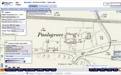
1) Here's an image of Paulsgrove. I believe the house is the oblong shape on the right, with a footpath around it.
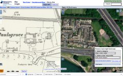
2) Next is an image of the same historical map side by side with its modern counterpart. When you're on the actual website you can move a cursor around and it shows you the same spot on the modern map, which here you can see at the small cross in the trees. That's where I think the house was. The trees, which must have been planted after the 1970 demolition.
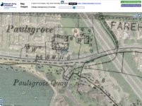
3) Finally, a fun image which is really specific - an overlay of old and new maps. You can vary this yourself. One other thing I was interested to note was that the modern land edge is different from the original one - it's been infilled. You should to be able to go straight to this at
https://maps.nls.uk/geo/explore/print/#zoom=18.0&lat=50.84696&lon=-1.10181&layers=6&b=ESRIWorld&o=60.
Hope this helps!

 www.google.com